KEY POINTS
- Record early April warmth is being replaced by an Arctic cold front, bringing temperatures back down to seasonal averages or below.
- Northern regions, particularly Scotland, should prepare for hill snow and blustery showers, while rural areas across the UK face a renewed risk of overnight frost.
- Strong winds and heavy rain are contributing to localized travel delays, including flight disruptions at major London airports and hazardous driving conditions on high-altitude routes.
After a week that saw the United Kingdom basking in the warmest temperatures of the year so far, a dramatic weather shift is currently sweeping across the British Isles. Meteorologists warn that the record-breaking early April heat is being abruptly replaced by a cold front traveling south from the Arctic. For American travelers and expats in the region, the sudden transition from t-shirt weather to winter coats serves as a stark reminder of the volatility of the North Atlantic jet stream.+1
What You Need to Know
The early days of April 2026 provided a rare spring treat for the UK, with some regions in the southeast experiencing temperatures soaring into the low 20s Celsius (low 70s Fahrenheit). This surge in warmth was driven by a high-pressure system drawing air from the south, briefly offering a summer-like atmosphere that saw parks and coastal resorts crowded across England and Wales. However, as is common in the British Isles, these “mini-heatwaves” are often the precursor to significant atmospheric instability.+1
The current disruption follows closely on the heels of Storm Dave, which battered northern parts of the country during the Easter weekend. While the storm has since cleared into the North Sea, it left the door open for a much colder air mass to descend from the north. The Met Office indicates that the transition is not merely a return to average spring conditions, but a sharp “Arctic plunge” that will bring overnight frosts and wintry precipitation to higher elevations.
This pattern of “weather whiplash” is becoming increasingly scrutinized by climate scientists. The rapid oscillation between unseasonable heat and late-season snow is a hallmark of a disrupted polar vortex. While the UK is accustomed to “April showers,” the intensity of the current cold front is expected to challenge local infrastructure, particularly in northern Scotland and Northern Ireland, where blustery winds are expected to make temperatures feel significantly colder than the mercury suggests.
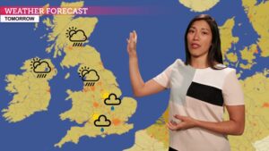
The Met Office Forecast: Wind, Rain, and Wintry Peaks
The UK weather forecast for the remainder of the week highlights a divided nation. As the cold front pushes south and east, the unseasonable warmth will be completely eroded by Friday evening. Widespread showers are forecast to become the norm, with some turning heavy and thundery. In northern Scotland, the precipitation is expected to turn to snow over high ground, with accumulations possible on the peaks as temperatures at altitude drop below freezing.
Wind speeds remain a primary concern for the national weather service. A deep area of low pressure situated to the northwest is generating gusts that could reach 40-50 mph in exposed coastal areas. These “blustery” conditions are expected to persist through the weekend, complicating outdoor plans and potentially impacting ferry services in the Irish Sea and the Hebrides. The Met Office has advised the public to remain “weather aware,” particularly those planning to travel through higher routes in the Pennines or the Scottish Highlands.+2
As we move into the early part of next week, the forecast remains highly unsettled. While there are glimpses of brighter interludes in the southeast, the general trend points toward a continuation of the “showery carousel.” Temperatures are expected to struggle, with daytime highs ranging from 8°C (46°F) in the north to roughly 13°C (55°F) in the south. Overnight, rural areas should prepare for a renewed risk of ground frost, which could pose a threat to early-blooming gardens and local agriculture.+1
The uncertainty in the long-range model solutions suggests that another low-pressure system may develop to the southwest by Tuesday. If this system moves inland, it could bring a more prolonged spell of heavy rain to England and Wales. Meteorologists are closely monitoring the positioning of the jet stream, as a slight shift could either trap the UK in this chilly, damp cycle or allow a ridge of high pressure to bring back more settled, albeit cooler, conditions.
Why This Matters
For Americans traveling in the UK or business professionals managing transatlantic operations, this sudden cooling has practical implications for logistics and safety. The drastic shift in temperature increases the likelihood of “black ice” on rural roads during the early morning hours, a hazard that may catch drivers off guard after a week of mild weather. Furthermore, the persistent wind and rain have already contributed to a surge in flight delays at major hubs like London Heathrow and Gatwick, as airlines adjust to decreased visibility and challenging crosswinds.
For the global community, this weather event highlights the fragility of the European energy and agricultural sectors during the spring transition. Sudden frosts following a period of record warmth can devastate fruit crops and early spring plantings, potentially leading to price fluctuations in local markets. Additionally, the return to cold weather triggers an unseasonable spike in heating demand, a factor that energy analysts watch closely as the continent continues to navigate its transition toward more sustainable power sources.
NCN Analysis
The current UK weather pattern is a classic example of a “blocked” atmospheric flow. When high pressure stays stationary over the Atlantic, it forces cold Arctic air to dive south over the British Isles. At NextClickNews, we see this as a critical period for travelers to exercise “situational flexibility.” The days of predictable, moderate spring weather in Northern Europe appear to be fading, replaced by extreme swings that require more robust contingency planning.
Looking ahead, the primary thing to watch is the recovery of the jet stream. If it remains “wavy” and displaced to the south, the UK could be in for a particularly damp and cool April. We recommend that readers keep a close eye on the “10-day trend” updates from the Met Office, as the current volatility means that a forecast can change significantly within a 24-hour window. The “Big Heat” of early April was a pleasant anomaly, but the “Big Chill” currently arriving is the reality of spring in 2026.
The British spring has hit the reset button, trading record-breaking sun for an Arctic-led return to winter-lite conditions.
Reported by the NCN Editorial Team.