KEY POINTS
- A major atmospheric shift is pushing freezing Arctic air into the Eastern United States this February.
- Record-breaking high temperatures are simultaneously impacting the West as a massive ridge of high pressure builds.
- Meteorologists attribute this dramatic “weather see-saw” to a buckling jet stream that alters typical winter patterns.
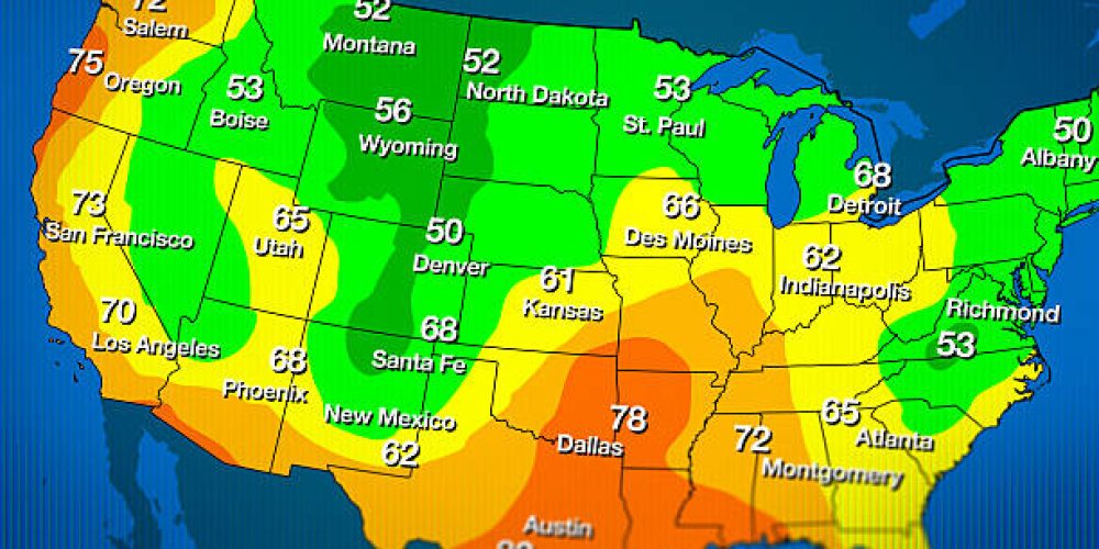
The United States is currently experiencing a stark climatic divide. A significant shift in atmospheric pressure has created two very different winter stories across the country. Cold air from the Arctic is plunging deep into the Eastern half of the nation. Meanwhile, the Western states are enjoying a surge of unseasonable warmth.
This phenomenon stems from a dramatic bend in the jet stream. In the West, a high-pressure ridge is acting like a physical barrier. This ridge deflects cold air and allows warm, subtropical air to move northward. Cities in California and the Pacific Northwest may see record highs for the month.
The East is seeing the opposite effect of this atmospheric ripple. A deep trough has opened, allowing the polar vortex to leak southward. This brings sub-freezing temperatures to the Great Lakes and the Northeast. Residents should prepare for a sharp contrast to the mild conditions experienced earlier this season.
Forecasters call this pattern the “Western Ridge, Eastern Trough” setup. It often results in prolonged periods of stable weather for both sides of the country. For the West, this means clear skies and a lack of significant precipitation. For the East, it brings a persistent risk of snow and ice.
This weather flip carries significant implications for energy consumption and agriculture. Western farmers may worry about early budding due to the warmth. Eastern homeowners will likely see a spike in heating costs as the mercury drops. Utility companies are already bracing for increased demand on the power grid.
Scientists note that these extreme atmospheric bends are becoming more common. A warming climate may be making the jet stream more prone to these dramatic oscillations. When the jet stream slows down, these hot and cold pockets tend to stay in place. This leads to longer-lasting weather events that can impact infrastructure.
The current forecast suggests this pattern will hold for at least the next ten days. Travelers should monitor conditions as storms may develop along the boundary of these two air masses. Flight delays are possible in the East due to wind and freezing rain. The West remains largely free of major weather-related travel hazards for now.
As February continues, the contrast between the coasts will likely sharpen. Monitoring local alerts is essential for those in the path of the Arctic air. The Western warmth provides a temporary reprieve from winter, but also raises drought concerns. This see-saw effect highlights the complexity of the modern North American climate.


