KEY POINTS
- London’s temperatures surged to a record-breaking 26°C on Wednesday, surpassing holiday destinations like Barcelona and marking the hottest day of 2026.
- The sudden heatwave follows a disruptive Easter weekend dominated by Storm Dave, which brought 90mph winds and blizzard conditions to northern regions.
- Meteorologists warn of a sharp “temperature crash” as a cold front moves in, potentially bringing a 10-degree drop within 24 hours.
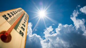
London has officially become the warmest spot in Europe this week, with temperatures hitting a blistering 26°C (79°F) as a rare plume of North African air swept across the British capital. The unseasonal heat has seen the city surpass traditional Mediterranean hotspots like Barcelona, providing a stark contrast to the wintry chaos experienced just days ago. For residents and travelers alike, this dramatic swing in weather marks a record-breaking peak in what has been a highly volatile spring.
What You Need to Know
The current weather pattern in the United Kingdom is a case study in meteorological extremes. Just last week, the country was reeling from the impact of Storm Dave, a powerful low-pressure system that battered Scotland, Wales, and Northern Ireland with gusts exceeding 90mph. That storm brought the UK’s spring momentum to a grinding halt, causing widespread power outages and dumping significant snow across upland areas, forcing many to abandon their Easter holiday plans.+1
However, the departure of Storm Dave into the North Sea cleared the way for a high-pressure ridge to draw in exceptionally warm air from the south. This “Spanish Plume” effect is responsible for the current surge in temperatures, which has seen the mercury rise nearly 15 degrees above the April average in some southern counties. This type of rapid oscillation—from blizzard conditions to summer-like heat within the span of 72 hours—is becoming an increasingly frequent characteristic of the UK’s changing climate.
The Met Office has noted that while these warm spells are welcomed by the public, they carry significant implications for infrastructure and health. The sudden transition can cause issues for the UK’s transport networks, which are often more prepared for damp, temperate conditions than for sudden heat or late-season snow. Furthermore, the record 26°C recorded in London on April 8th is significantly higher than the previous 2026 high of 20.9°C, set in Wales only a few weeks prior.
From Storm Dave to a Record-Breaking Heatwave
The trajectory of this week’s weather began with the naming of Storm Dave on April 2nd. The system deepened rapidly as it crossed the Atlantic, hitting the UK over the Easter weekend. While the north faced amber warnings for wind and disruptive snow, the south remained relatively sheltered, though still breezy and cool. As the storm moved east, it left behind a vacuum that was quickly filled by a settled, warm air mass. By Tuesday, the shift was palpable, with Londoners trading winter coats for short sleeves almost overnight.+2
Wednesday’s peak of 26°C in the capital was mirrored by unseasonably warm conditions in Manchester and parts of Wales, where highs reached 21°C. This brief but intense spell of warmth has prompted health officials to issue reminders regarding sun safety, particularly as the UK’s population is not yet acclimated to such high UV levels so early in the year. The contrast with Barcelona, which sat at a comparatively modest 19°C on the same day, highlights just how anomalous this specific weather event has been.
However, the Met Office is already signaling the end of this “mini-summer.” A cold front is currently tracking toward the UK from the northwest, expected to collide with the warm air mass by Friday. This transition is likely to be turbulent, with the potential for heavy thundery showers and a significant “temperature crash.” Forecasters predict that by the weekend, London’s highs will return to a more typical 15°C or 16°C, effectively ending the record-breaking run.
The volatility doesn’t stop with the heat; the upcoming week is expected to return to an unsettled theme. Further bands of rain and cloud are forecast to move in from the west, maintaining the “April showers” reputation that was briefly forgotten during Wednesday’s sunshine. For those tracking the data, 2026 is already shaping up to be a year of significant climate records, with Storm Dave and this week’s heatwave serving as the primary bookends for a wild start to the second quarter.
Why This Matters
For American travelers and global businesses, the UK’s extreme weather swings have a direct impact on logistics and travel safety. The North Atlantic remains the primary corridor for international flights between the U.S. and Europe; storms like Dave can cause massive flight delays and cancellations that ripple through global hubs like Heathrow and JFK. Conversely, record heat in London can stress aging infrastructure, such as the London Underground, which lacks widespread air conditioning, affecting the productivity and comfort of international business travelers.
Beyond travel, these patterns are a signal for global energy and insurance markets. The rapid transition from heating demand during Storm Dave to a sudden spike in cooling needs (and the subsequent risks of flash flooding from thundery breakdowns) creates volatility in utility consumption. For the global reader, the UK’s weather is a bellwether for the North Atlantic’s broader climate health, providing early data on how shifting jet stream patterns are creating more intense and frequent weather anomalies across the Northern Hemisphere.
NCN Analysis
While the 26°C high in London is a headline-grabber, the real story is the speed of the transition. The fact that the UK can move from 90mph “Storm Dave” winds to record heat in less than a week suggests a jet stream that is increasingly “buckled,” allowing for deep incursions of both polar and tropical air. At NextClickNews, we anticipate that this will lead to a more unpredictable summer season across Europe. If the current pattern holds, we could see a cycle of intense heat followed by violent storm systems throughout June and July.
Readers should watch the weather reports closely for the coming 48 hours. The “breakdown” of this heatwave often brings the risk of lightning and localized flooding, which can be just as disruptive as the wind and snow of the previous week. We recommend that those with outdoor plans or travel arrangements in the UK stay “weather aware,” as the return to cooler, unsettled conditions will likely be as sudden as the arrival of the heat itself.
The record-breaking April heat is a welcome reprieve for some, but it serves as a stark reminder of the volatile atmospheric forces at play over the British Isles.
Reported by the NCN Editorial Team