KEY POINTS
- A powerful surge of Canadian Arctic air will collide with warm, moist air early next week, triggering a disruptive mix of snow, sleet, and freezing rain.
- Temperatures in major hubs like New York City will plummet from near 50°F on Saturday to the 20s by Monday, causing rapid freezing of wet surfaces.
- Major travel disruptions are expected from Monday through Wednesday, potentially impacting airline hubs from Chicago and Detroit to the mid-Atlantic coast.
The United States is bracing for a dramatic shift in weather as a fresh surge of Arctic air moves southeastward from Canada. This cold front is expected to set the stage for a significant winter storm early next week, threatening to bring disruptive snow and ice to a massive corridor stretching from the Midwest to the Northeast. While the weekend might begin with a brief, spring-like warmup in some areas, meteorologists warn that the pleasant conditions will be short-lived. By Sunday and Monday, a deep freeze will settle over the region, turning slushy streets into hazardous ice rinks and creating challenging conditions for commuters and travelers alike.
Before the main storm system arrives, several smaller “clipper” events will move through the northern tier of the country. A narrow band of snow is forecast to develop from Montana through the Dakotas, eventually reaching the Great Lakes by Friday night and Saturday. Cities like Chicago and Detroit are expected to see light accumulations during this period, but these early rounds are merely the precursor to the more potent system building for the start of the work week. The arriving Arctic high pressure will be the “key ingredient” for this next phase, providing the necessary sub-freezing temperatures for heavy wintry precipitation.
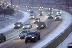
The temperature contrast will be particularly stark in the Northeast and mid-Atlantic. In New York City, residents could see afternoon highs near 50°F on Saturday before temperatures crash into the 30s on Sunday and struggle to break out of the 20s by Monday. This rapid cooling creates a significant risk of a “flash freeze.” Any runoff from melting snow or recent rain will likely turn into standing ice, making sidewalks and secondary roads treacherous for pedestrians and drivers. Officials are urging the public to be cautious of ponding on city streets during the brief Saturday thaw.
By Sunday and into early Monday, the collision of moisture and Arctic air will likely produce a zone of heavy snow and ice from northern Missouri through central Indiana and Ohio. As the storm tracks further east, it will take aim at the central Appalachians and the mid-Atlantic coast later on Monday. While forecasters do not expect this system to rival the historic “Blizzard of 2026,” it is still expected to bring several inches of snow to areas that may have missed out on previous wintry events. The exact amount of accumulation will depend heavily on the storm’s final track and how quickly rain transitions to snow.
The period from Monday through Wednesday carries the highest risk for significant travel delays. Major airport hubs including Washington, D.C., Philadelphia, Boston, and New York City are all within the potential impact zone. Depending on the storm’s intensity, freezing rain and sleet could become the primary concern for the I-95 corridor, leading to power outages and dangerous flight conditions. Meanwhile, areas further south that experience primarily rain may face urban flooding as heavy downpours hit frozen or saturated ground.
Looking further into the week, a secondary storm system could follow closely behind from Tuesday to Wednesday. This one-two punch of winter weather ensures that the transition from February to March will be a cold and snowy one for much of the eastern half of the country. If the primary storm tracks further north, meteorologists are also concerned about the possibility of ice jams on rivers and streams, which could lead to localized flooding in interior regions.
Public safety officials are encouraging residents to prepare for the upcoming cold blast by checking emergency kits and monitoring local forecasts frequently. With the Arctic surge firmly in place, the margin for error in travel plans will be slim throughout the early part of next week. As the collision of air masses intensifies, the Midwest and Northeast must prepare for a multi-day stretch of volatile winter weather that will test the resilience of the region’s infrastructure once again.