KEY POINTS
- Forecasters warn of a “bomb cyclone” intensification, with snowfall rates reaching 3 inches per hour and visibility dropping to near zero across major metropolitan hubs.
- Emergency travel bans are in effect for New York City and New Jersey, while over 500,000 residents are already without power due to heavy, wet snow and hurricane-force gusts.
- The storm is expected to rank among the top-10 heaviest snowfalls in NYC history, with some coastal regions bracing for up to 30 inches of accumulation by Monday night.
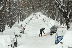
The Northeastern United States is currently in the grip of a potentially historic winter event as a powerful nor’easter, referred to by many as the Blizzard of 2026, batters the region from Delaware to Maine. What began as a complex weather system moving across the country has rapidly intensified off the Atlantic coast into a “bomb cyclone.” This explosive strengthening has prompted the National Weather Service to issue blizzard warnings for the first time in several years for major cities including New York and Boston. With over 40 million people in the storm’s path, officials are urging residents to stay indoors as conditions transition from dangerous to life-threatening.
In New York City, Mayor Zohran Mamdani has enacted a citywide travel ban on all non-essential vehicles, highways, and bridges. The move comes as meteorologists predict snowfall totals could reach between 16 and 28 inches, potentially surpassing records set during the 2016 blizzard. For the first time since 2019, New York City Public Schools have canceled all classes, including remote learning, to prioritize safety. The storm’s arrival was marked by the rare phenomenon of thundersnow, with lightning strikes even hitting One World Trade Center during the height of the whiteout conditions early Monday morning.
The impact on infrastructure has been immediate and severe. More than 6,000 flights have been grounded at major hubs like JFK, Newark, and Boston Logan. On the ground, NJ Transit has suspended bus and light rail services, while highways across the I-95 corridor have seen speeds reduced or travel banned entirely. Utility companies are struggling to keep up with surging power outages, which have already affected half a million customers. The combination of heavy, wet snow and wind gusts ranging from 50 to 80 mph is snapping tree limbs and bringing down power lines, particularly in coastal New Jersey and Long Island.
Coastal communities are facing a dual threat of heavy snow and significant flooding. A storm surge of 2 to 4 feet is expected during high tide cycles, threatening low-lying neighborhoods from the Delaware Bay to Cape Cod. Emergency management coordinators in Atlantic City have warned that floodwaters may be hidden under rapidly accumulating snow, creating “trap” conditions for any motorists who venture out. Residents in these areas are being advised to treat the situation with the same level of caution as a Category 2 hurricane, given the sustained wind speeds and potential for structural damage.
While the storm is expected to begin tapering off by late Monday evening, the cleanup process will be hampered by lingering winds. Even after the snow stops falling, blowing and drifting snow will continue to reduce visibility and recover roads that have been plowed. Forecasters note that the “bull’s-eye” of the heaviest accumulation remains centered on southeast New England and Long Island, where some areas have already surpassed 20 inches of snow. As the system moves toward northern New England on Tuesday, it leaves behind a region transformed by one of the most significant winter weather events of the decade.
The sudden intensity of the storm caught many by surprise, as early weekend forecasts fluctuated between a minor dusting and a major event. However, atmospheric shifts on Friday afternoon pushed modeling toward this extreme outcome. Experts emphasize that the wet, heavy nature of this snow makes it particularly dangerous for those attempting to shovel, advising citizens to take frequent breaks and monitor for physical strain. As the Northeast hunkers down, the focus remains on essential services and emergency response until the blizzard finally departs into the North Atlantic.