KEY POINTS
- An Alberta clipper system brought late-season snow to major Northeast cities on Monday.
- Temperatures plunged up to 20 degrees following a period of historic spring warmth.
- Freeze warnings are in effect as wind chills drop into the 20s through Wednesday.
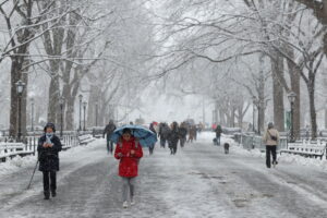
A sudden shift in weather patterns has brought a wintry chill back to the northeastern United States. Just days after enjoying record-breaking warmth, residents woke up to a fast-moving cold front. This system, known as an Alberta clipper, swept across the region early Monday morning. It delivered a fresh layer of snow to states stretching from New York to Vermont.
Syracuse and other parts of Upstate New York saw the first signs of accumulation before dawn. The snowfall then expanded into major metropolitan areas including Boston and Buffalo. Even New York City reported light flurries as the system moved through the coastal corridor. Most areas received between one and three inches of snow during the brief event.
This late-season blast follows a historically active winter for many coastal communities. Providence, Rhode Island, recently set a new all-time record for a single snowstorm. The current clipper serves as a reminder of the unpredictable nature of spring weather. Higher elevations in the Adirondacks could see slightly higher snow totals before the system exits.
Temperatures have dropped sharply in the wake of the cold front. Monday highs struggled to reach the 40s and 50s across much of the region. This represents a decline of 10 to 20 degrees compared to previous days. While these levels are near seasonal averages, the change felt dramatic after the recent heat.
The coldest conditions are expected to arrive by Wednesday morning. Forecasters predict wind chills will dip into the 20s for many interior locations. These freezing temperatures have prompted officials to issue frost and freeze alerts. Such warnings are critical for farmers and gardeners at the start of the growing season.
The cold air mass will linger from the Great Lakes to New England through midweek. Experts note that measurable snow in mid-April is not entirely uncommon for the area. However, the contrast with last week’s record highs makes this event particularly notable. Residents are encouraged to protect sensitive plants from the upcoming overnight freezes.
A recovery in temperatures should begin by Thursday afternoon. The region will see a return to more typical spring conditions as the week ends. Until then, winter clothing remains necessary for those heading outdoors. The FOX Forecast Center continues to monitor the system as it moves toward the Atlantic.