KEY POINTS
- Severe Tropical Cyclone Narelle has re-intensified into a Category 3 system off the Western Australia coast after already making three separate landfalls across northern Australia.
- Meteorologists forecast the storm could reach high-end Category 4 or even Category 5 intensity before striking the Gascoyne coast late Friday or early Saturday.
- The cyclone’s unusual path toward the south-west puts highly populated areas, including Perth, at risk of significant rainfall and damaging winds.
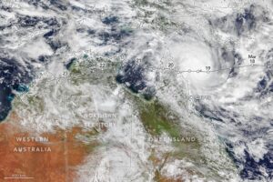
A relentless weather system is poised to make history as it prepares for a rare fourth strike on the Australian continent. Tropical Cyclone Narelle which originally formed in the Coral Sea, has spent the last week traversing the northern edge of the country, leaving a trail of flooding and wind damage in its wake. After moving offshore into the Indian Ocean, the system found favorable conditions, including exceptionally warm sea surface temperatures, allowing it to regain severe tropical cyclone status. This re-invigoration has triggered a new wave of emergency preparations along the Western Australian coastline.
The storm’s journey began with a powerful Category 4 landfall on Queensland’s Cape York Peninsula on March 20. It then weakened into a tropical low while crossing the Northern Territory, only to re-intensify and strike the Kimberley region. This “triple-landfall” event is already considered a rare meteorological occurrence, but the current trajectory suggests Narelle is not yet finished. The Bureau of Meteorology notes that the system is now tracking south-west, parallel to the Pilbara coast, and is expected to take a sharp southern turn that will bring it into direct contact with the central-west coast of Western Australia.
Current forecasts indicate that Narelle could peak in strength as it approaches the North West Cape. Residents in towns like Exmouth and Onslow are bracing for very destructive wind gusts that could exceed 260 km/h. The primary concern for emergency services is the storm’s unusually large wind field, which means that even a near-miss could result in widespread power outages and structural damage. Additionally, the storm is carrying a massive amount of moisture, with some regions expecting up to 230 mm of rain within a 24-hour period, heightening the risk of flash flooding in areas already saturated by a heavy wet season.
The long-term path of the cyclone is particularly concerning for southern Western Australia. While most tropical systems dissipate or move inland far to the north, Narelle is expected to hug the coast toward Shark Bay and potentially move as far south as Perth. Although the system will likely weaken as it enters cooler waters, it could still bring heavy tropical rains and blustery conditions to the state capital by the weekend. Such a southerly track for a tropical cyclone is infrequent, with comparisons being drawn to significant historical events like Cyclone Alby in 1978 and Cyclone Seroja in 2021.
Local governments and disaster response agencies have activated emergency protocols across the Gascoyne and Mid West regions. In Shark Bay, where the storm is currently forecast to make its final landfall, residents and tourists have been advised to finalize their cyclone preparations and secure loose items. Evacuation centers are being readied in low-lying areas, and maritime authorities have issued warnings for abnormally high tides and dangerous surf conditions. The potential for the storm to transition into a powerful mid-latitude system means that its impacts could be felt hundreds of kilometers away from its center.
As Narelle continues its 5,500-kilometer trek around the continent, it serves as a stark reminder of the increasing volatility of the Australian cyclone season. The storm has already impacted three different states and territories, a feat not seen in over two decades. With the final landfall imminent, meteorologists are urging the public to stay updated with the latest tracking maps, as the dynamic nature of the system means its exact crossing point could still shift. The coming days will determine if Narelle will be remembered not just for its longevity, but for the severity of its impact on Western Australia’s coastal communities.