KEY POINTS
- A storm chaser captured a rare moment of meteorological beauty as a vibrant double rainbow formed in the wake of severe Illinois weather.
- The footage provides a stark contrast between the calming atmospheric optics and the volatile storm environment active in the region.
- Experts highlight that such phenomena occur when sunlight refracts and reflects twice inside water droplets during high-moisture storm exits.
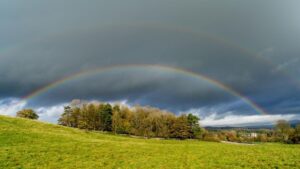
Nature displayed a striking visual contrast in the Midwest this week as a professional storm chaser filmed a brilliant double rainbow over the Illinois landscape. The video, captured during a high-stakes pursuit of a severe weather system, shows the secondary arc forming clearly above the primary rainbow. This rare optical event occurred just as the heavy precipitation began to clear, allowing sunlight to interact with the retreating storm wall. The footage has quickly gained attention for its high definition and the unusual clarity of the color bands against a dark, bruised sky.
The timing of the appearance was particularly notable, as the region had just been under multiple severe thunderstorm and tornado warnings. Storm chasers, who typically focus on the destructive elements of the atmosphere, were treated to this brief moment of tranquility as the system moved eastward. Meteorological experts explain that a double rainbow is produced when light reflects twice inside rain droplets, causing the colors of the outer arc to appear in reverse order compared to the inner one. While single rainbows are common, the atmospheric conditions required for such a well-defined second arc are much harder to document during active chases.
Illinois has seen a significant uptick in severe weather activity recently, with several storm systems bringing both high winds and heavy rainfall to the central and northern parts of the state. The specific storm that produced this double rainbow was part of a larger front that triggered localized flooding and power outages. However, the positioning of the observer between the departing rain and the emerging sun created the perfect “rainbow window.” The chaser managed to stabilize the camera despite the windy conditions to catch the exact moment the secondary bow intensified.
This visual phenomenon serves as a reminder of the complex dynamics at play during the spring storm season in the United States. While the primary focus for residents is safety and property protection, the science of storm chasing often yields incredible data and imagery regarding how light and water interact in extreme environments. The video highlights how quickly the atmosphere can shift from a state of danger to one of aesthetic wonder. For many viewers, the image of the arches stretching across the rural horizon provided a welcome break from the standard footage of dark funnel clouds and debris.
Data from the event shows that the colors were exceptionally vivid due to the large size of the raindrops within the trailing edge of the supercell. Larger drops typically produce more brilliant and distinct color separation in a rainbow. In this instance, the dark clouds behind the rainbow provided a high-contrast backdrop that made the neon-like glow of the violet and red bands stand out more than usual. The chaser noted that the double rainbow remained visible for several minutes before the sun was again obscured by trailing clouds.
As digital media continues to play a role in weather reporting, high-quality clips like this are becoming essential for educational purposes. They help the general public understand the lifecycle of a storm and the various stages of atmospheric clearing. This specific Illinois chase will likely be remembered as much for its stunning finale as for the intensity of the storm itself. The combination of professional-grade cinematography and a perfectly timed natural event has created one of the most shared weather videos of the year.