KEY POINTS
- A major cold front is moving into the Central and Southern Plains, significantly lowering temperatures and raising humidity levels after days of extreme fire risk.
- Recent wildfires fueled by 100 km/h winds have already devastated over 122,000 hectares in Oklahoma and destroyed hundreds of homes across several states.
- While the immediate threat is subsiding, meteorologists warn that persistent drought conditions across 45% of the U.S. may lead to a volatile early spring fire season.
Residents across the American Plains are finally seeing a break from a period of historical wildfire danger that has plagued the region throughout mid-February. A powerful weather system is currently transiting the central United States, bringing much-needed moisture and cooler air to areas that were previously under Red Flag Warnings. This shift in the atmospheric pattern arrives as a vital relief for emergency crews who have been battling fast-moving grass fires fueled by unseasonably warm temperatures and intense wind gusts.
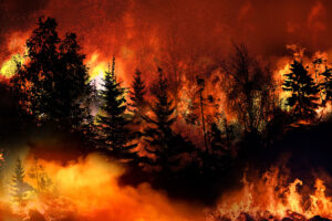
The conditions leading up to this reprieve were nothing short of catastrophic for several communities. Earlier in the week, a combination of record-breaking warmth and a strong pressure gradient created a “perfect storm” for fire ignition. In states like Oklahoma, Texas, and Kansas, winds exceeding 60 mph combined with relative humidity levels dropping into the single digits. This environment allowed even small sparks to explode into massive conflagrations that jumped highways and forced the evacuation of thousands of residents.
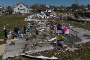
In Oklahoma alone, the damage has been profound, with reports indicating the loss of over 400 homes and massive agricultural impacts. The speed of the fire spread was accelerated by dormant winter grasses, which served as highly combustible fuel. Because the region has experienced a significant lack of precipitation over the last 60 days, the ground was primed for disaster. The situation became so dire that multiple states activated emergency response protocols and agricultural relief measures to assist farmers and ranchers who lost livestock and infrastructure.
The incoming cold front is expected to provide a “wetting rain” for some areas, which is defined as enough precipitation to thoroughly soak the top layer of dry vegetation. In addition to the moisture, the sharp drop in temperature will help to stabilize the atmosphere and reduce the “mixing” of dry air from higher altitudes. This change allows fire suppression teams to gain the upper hand on existing hotspots and reduces the likelihood of new ignitions from human activity or equipment sparks.
However, long-range forecasters at AccuWeather caution that this relief may be temporary. The broader climate picture shows that nearly half of the contiguous United States is currently suffering from some level of drought. As spring approaches, the “green-up” of vegetation—where new, moisture-filled plants replace dry, dead grass—has not yet occurred in the Northern and Central Plains. This means that any return to warm, windy weather could quickly reignite the fire threat before the summer rainy season begins.
For now, the focus remains on recovery and vigilance. Emergency management officials are encouraging residents to use this period of calmer weather to clear defensible space around their properties and update their evacuation plans. While the smoke is clearing and the winds are dying down, the events of this week serve as a stark reminder that wildfire season is no longer confined to the summer months, necessitating year-round awareness in the Plains.