KEY POINTS
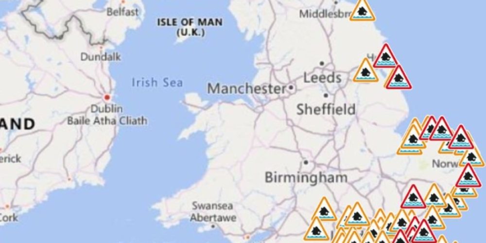
- The Environment Agency issued over 60 flood warnings and alerts as heavy rain continues to soak the UK.
- Met Office forecasters expect the unsettled weather to persist throughout the week with more downpours.
- Ground saturation remains high across southern regions, increasing the immediate risk of surface water flooding.
The United Kingdom faces another week of significant weather disruption as heavy rain continues to fall. Meteorologists expect the current wet spell to last several more days. This persistent rainfall follows a series of storms that have already left the ground heavily saturated. The Environment Agency has responded by issuing dozens of flood warnings across many parts of England.
Government officials currently list more than 20 flood warnings where immediate action is necessary. They also remain on high alert with over 40 flood alerts for other vulnerable areas. These alerts signify that flooding is possible and residents should prepare accordingly. Emergency teams are monitoring river levels closely as they continue to rise in response to the runoff.
Southern England and the Midlands currently face the highest risk of flooding. The Met Office indicates that a series of low-pressure systems will move across the Atlantic. These systems bring moisture-laden air that results in prolonged periods of rainfall. Many communities are already struggling to cope with the sheer volume of water entering drainage systems.
Travelers should expect significant delays on both roads and rail networks this week. Surface water on motorways has already caused several minor accidents and slow-moving traffic. Rail operators warned that flooded tracks might force sudden cancellations or speed restrictions. Commuters are advised to check official transport apps before starting their morning journeys.
The impact of the weather extends beyond travel to local businesses and homeowners. Many residents in low-lying areas have already deployed sandbags to protect their properties. Local councils are working to clear blocked culverts and drains to prevent further water accumulation. However, the intensity of the rain often outpaces these mitigation efforts.
Environmental experts point to the current state of the soil as a major concern. Because the ground is so wet, it cannot absorb any more precipitation. This means almost all new rainfall runs directly into already swollen rivers and streams. This phenomenon creates a rapid rise in water levels that can catch residents by surprise.
Temperatures remain relatively mild for February, which prevents the moisture from falling as snow. While this avoids some winter hazards, the volume of liquid rain remains the primary threat. Forecasts suggest that drier conditions may not arrive until much later in the month. Until then, the public is urged to stay informed through official weather channels.


